Keywords
Collection #
Collection Name Collection #
Author Date
Description
Microfilm Number
Series Number

Inventory for MSA SC 5796-12


MSA SC 5796-12 contains 21 unit(s). Showing results 1 to 15.

Results Per Page:

Return to Collection Information

12
MSA SC 5796-12-1
Dates1606-1624
MediumOriginal
StorageContact the Department of Special Collections for location.
Description
Smith, John, 1580-1631.

Virginia / discovered and discribed by Captayn John Smith, 1606 ; graven by William Hole. CREATED/PUBLISHED [London ; 1624] NOTES Sixth state. Relief shown pictorially. Oriented with north to the right. Accompanied by 2 exhibit notes and LC jacket note. SUBJECTS Virginia--Maps--Early works to 1800. United States--Virginia. RELATED NAMES Hole, William, d. 1624. MEDIUM 1 map ; 32 x 41 cm. CALL NUMBER G3880 1624 .S541 Vault CONTROL NUMBER 99446115 REPOSITORY Library of Congress Geography and Map Division Washington, D.C. 20540-4650 USA

MSA SC 5796-12-2
Dates1792-1887
MediumOriginal
StorageContact the Department of Special Collections for location.
Description

Plan of the city intended for the permanent seat of the government of t[he] United States : projected agreeable to the direction of the President of the United States, in pursuance of an act of Congress passed the sixteenth day of July, MDCCXC, "establishing the permanent seat on the bank of the Potowmac" : [Washington D.C.] / by Peter Charles L'Enfant. L'Enfant, Pierre Charles, 1754-1825. CREATED/PUBLISHED [Washington : U.S. Coast and Geodetic Survey, 1887] NOTES Photocopy of a facsim. Of the 1791 L'Enfant plan. Original facsim. Extensively annotated in ink by Lawrence Martin, chief, Division of Maps, Library of Congress. Includes text, indexed "References," and photocopied newspaper article titled "New city of Washington," from the Gazette of the United States, Philadelphia, Jan. 4, 1792. At lower right: N.I. LC copy torn, fold-lined, taped, and accompanied by another photocopy at a smaller scale.

MSA SC 5796-12-3
Dates1792
MediumOriginal
StorageContact the Department of Special Collections for location.
Description
Ellicott, Andrew, 1754-1820.

Plan of the city of Washington in the territory of Columbia : ceded by the states of Virginia and Maryland to the United States of America and by them established as the seat of their government after the year MDCCC / engrav'd by Sam'l Hill, Boston ; in order to execute this plan, Mr.Elicott drew a true medidional line…. Published: [Boston : s.n., 1792] LC Call No.: G3850 1792 .E48 VA-DC Bdy

MSA SC 5796-12-4
Dates1755-1771
MediumOriginal
StorageContact the Department of Special Collections for location.
Description
Evans, Lewis, 1700?-1756.

A general map of the middle British colonies in America, viz. Virginia, Maryland, Delaware, Pensilvania, New-Jersey, New York, Connecticut & Rhode-Island: of Aquanishuonigy the country of the confederate Indians comprehending Aquanishuonigy proper, their places of residence, Ohio & Thuchsochruntie their deer hunting countries, Couchsachrage & Skaniadarade their beaver hunting countries, of the Lakes Erie, Ontario and Champlain. Wherein is also shewn the antient & present seats of the Indian nations. Carefully copied from the original published at Philadelphia, by Mr. Lewis Evans. Philadelphia, 1755. See also the 1771 edition: London, Printed for Carington Bowles, 1771. LC Call No.: G3710 1771 .E835 Vault

Note that Maryland's boundary with Virginia is denoted as extending to the Southern Shore of the Potomac:


MSA SC 5796-12-5
Dates1751-1775
MediumOriginal
StorageContact the Department of Special Collections for location.
Description
Fry, Joshua, 1700 (ca.)-1754.

A map of the most inhabited part of Virginia containing the whole province of Maryland with part of Pensilvania, New Jersey and North Carolina. Drawn by Joshua Fry & Peter Jefferson in 1751. London, Thomas Jeffreys [1775] LC Call No.: G3880 1775 .F7 Vault

MSA SC 5796-12-6
Dates1794
MediumOriginal
StorageContact the Department of Special Collections for location.
Description
Griffith, Dennis.

Map of the state of Maryland : laid down from an actual survey of all the principal waters, public roads, and divisions of the counties therein : describing the situation of the cities, towns, villages, houses of worship, and other public buildings, furnaces, forges, mills, and other remarkable places, and of the Federal Territory : as also a sketch of the state of Delaware, shewing the probable connexion of the Chesapeake and Delaware bays / by Dennis Griffith, June 20th 1794 ; engraved by J. Thackara & J. Vallance. Published: Philad[elphi]a : J. Vallance, 1795. LC Call No.: G3840 1794 .G73 VA-DC Bdy

For a discussion of the history of the creation of Griffith's map see: Edward C. Papenfuse and Joseph M. Coale III, The Maryland State Archives Atlas of Historical Maps of Maryland, 2003, pp. 72-75. Also below for an accurate rendition of the Maryland Virginia Boundary on a map published shortly after the Mount Vernon Conference.

MSA SC 5796-12-7
Dates1606-1908
MediumOriginal
StorageContact the Department of Special Collections for location.
Description
Analysis of maps relevant to the boundary disputes between Maryland and Virginia. [in progress]
MSA SC 5796-12-8
Dates1635
MediumOriginal
StorageContact the Department of Special Collections for location.
Description
[Jerome Hawley and John Lewger.

Noua Terrae-Mariae tabula, 1635, John Work Garrett Library, The Johns Hopkins University, MSA SC 1213-258, Edward C. Papenfuse, Jr. and Joseph M. Coale III, The Hammond Harwood House Atlas of Historical Maps of Maryland, 1608-1908. Baltimore: The Johns Hopkins University Press, 1982, p. 6.

MSA SC 5796-12-9
Dates1876
MediumOriginal
StorageContact the Department of Special Collections for location.
Description
Map of the Potomac River about the Great Falls Showing the Location of the Proposed Fish-Way." MSA SC 1427-596. From the Report of the Commissioners of the Fisheries of Maryland, January 1876.
MSA SC 5796-12-10
Dates1737
MediumOriginal
StorageContact the Department of Special Collections for location.
Description
Warner, John, fl. 1727-1741.
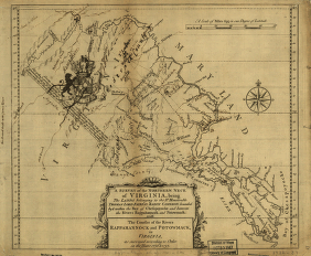
A survey of the northern neck of Virginia, being the lands belonging to the Rt. Honourable Thomas Lord Fairfax Baron Cameron, bounded by & within the Bay of Chesapoyocke and between the rivers Rappahannock and Potowmack: With the courses of the rivers Rappahannock and Potowmack, in Virginia, as surveyed according to order in the years 1736 & 1737.

CREATED/PUBLISHED: [n.p., 1747?]

NOTES: Scale ca. 1:875,000. Relief shown pictorially. Annotated to show roads, plantations, counties and towns. DLCA

A downloaded jpg2 version of this map is to be found here

Dan Guzy, author of numerous articles on the history of the Potomac River, including “The Potomac River Survey of 1822,” in the Maryland Historical Magazine, Winter 2009, points out that the provenance and attribution of this map, and those associated with the disputes over the boundaries of Lord Fairfax's grant of the Northern Neck of Virginia as surveyed by William Mayo, Benajmin Winslow and John Warner between 1736 and ca. 1747, are uncertain and conflicting.

According to Dan Guzy, Benjamin Winslow’s Potomac River map was published in James W. Foster’s “Maps of the First Survey of the Potomac River , 1736-1737” (William and Mary College Quarterly Historical Magazine, Vol. 18, No. 2, April 1938). Benjamin Winslow’s field notes (Mss11:3 W7326:1) are in the Thorton Perry collection at the Virginia Historical Society in Richmond", with a copy at the Berkeley County (WV) Historical Society." See: Elizabeth Cometti, “Concerning the First Survey of the Northern Neck” (West Virginia History, Vol. 2, No. 1, October 1940, pages 59-64).

Dan Guzy notes that "Fairfax Harrison’s “The Northern Neck Maps of 1737-1747” (William and Mary College Quarterly Historical Magazine, Vol. IV, No. 1, January 1924) discussed the Mayo and Warner maps as distinct “rival maps.” Mayo worked for the Crown (i.e., for Lt. Governor Gooch of Virginia ) and Warner, like Benjamin Winslow, worked for Lord Fairfax. Harrison quoted William Byrd (one of three commissioners on the Crown side) as saying Mayo’s map was formed “by joining all the particular surveys together.” Harrison said: “The map [i.e., Mayo’s, the Crown’s map] so identified was 32x32 inches in size, drawn on a scale of 5 miles = 1 inch, and bore the following legend: “A Map of the Northern Neck in Virginia, The Territory of the Right Honourable Thomas Lord Fairfax; Situate betwixt the Rivers Potowmack and the Rappahannock, according to the late Survey; Drawn in the year 1737, by Wm. Mayo.” [This is the same title as Foster used for the “Mayo” map in the Pratt library.]

Harrison described the Warner map as “no less than 42x80 inches in size, and represented a scale of 2½ miles = 1 inch. On its face it was ascribed as ‘Drawn by John Warner, Surveyr.’ Moreover, it carried the following certificate: “A true and accurate Survey of the Rivers Rappahannock and Patowmack to their first heads or Springs, done by order of the Commissioners as well as on the part of His Majesty as the Lord Fairfax. “CH. Carter, W. Beverly , W. Fairfax .” [These were the three commissioners for Lord Fairfax]. Harrison went on to say that Warner’s map was printed in a reduced size, 12x14 inches, so that it could be more easily handled by the King’s Privy Council."

Edward B. Mathews provides some clues to the mystery of these maps in his "Bibliography and Cartography of Maryland Resources," in the 1897 annual report of the Maryland Geological Survey, pp. 344-345, entries for 1737, 1738, and 1745, introducing another map maker, Thomas Lewis, adding further to the confusion. The principal contemporary source for the mapping of the Potomac, apart from Winslow's notes, cited above, is William Byrd's History of the Dividing Line, cited by Mathews. In 1898, in the annual report of the Maryland Geological Survey, Mathews writes extensively about "The "Mayo" map, 1736-7," pp. 388-391, based upon the William Byrd's account and his own observations of the map Byrd included in his work attributed to Mayo.

As Dan Guzy points out, the John Warner map at the Library of Congress has annotations on it later than 1747 (it depicts Fort Cumberland). Someone has annotated the LC copy that it is the 4th edition of the Warner map. It is stamped indicating acquisition? '1947' and there are two stamps indicating it came from the 'Bancroft' collection. [ecp 2009/08/25]

The Maryland State Archives has photostatic copies of two of the survey maps from the British National Archives (formerly the PRO) plus two other copies of the survey maps, one from the New York Public Library:

MSA SC 1427-1-1350, Cartographer: John Warner, 1737 & 1737, Disbound original map, A survey of the northern neck of Virginia, being the lands belonging to the Rt. Honourable Thomas Lord Fairfax Baron Cameron, bounded by & within the Bay of Chesapoycke and between the Rivers Rappahannock and Potowmack published in…

MSA SC 1399-1-305, Cartographer: William Mayo, 1737, A Map of the Northern Neck in Virginia, the Territory of the Right Honourable Thomas Lord Fairfax; situated betwixt the Rivers Patomack and Rappahanock photostat made from original in the Public Record Office, National Archives, Kew, Surrey, United Kingdom.

MSA SC 1399-1-328, Cartographer: John Warner, 1737, A Survey of the Northern Neck of Virginia, being the Lands belonging to the Right Honourable Thomas Lord Fairfax Baron Cameron photostat made from copy owned by Library of Congress Maps Division, produced from an original in the New York Public Library.

MSA SC 1399-1-381, Cartographer: William Mayo, 1737, A Map of the Northern Neck in Virginia situated betwixt the Rivers Potomack and Rappahanock photostat made from original in the Public Record Office, National Archives, Kew, Surrey, United Kingdom. A color version of this map is provided hereby Dan Guzy.

MSA SC 5796-12-11
Dates1911
MediumOriginal
StorageContact the Department of Special Collections for location.
Description
GARRETT COUNTY CIRCUIT COURT (Boundary Maps) Map showing the Boundary Line Between Maryland and West Virginia from the Potomac River to the Pennsylvania State Line as Surveyed and Marked under the decree of the United States Supreme Court [decision Rendered May 31, 1910], 1911 MSA C2480

Official copy of the Supreme Court map showing the western border between Maryland and West Virginia based upon the decision of the Supreme Court.

MSA SC 5796-12-12
Dates1988/02
MediumOriginal
StorageContact the Department of Special Collections for location.
Description
SPECIAL COLLECTIONS (Huntingfield Corporation Map Collection of the Maryland State Archives) National Oceanic and Atmospheric Administration Nautical Chart #12285 - "Potomac River-Washington, D.C.-Maryland-Virginia" [MSA SC 1399-935, B5-10-5]

Page B Inset 5 - Coles Point
jpg format
tif format

Page D Inset 9 - Colonial Beach
jpg format
tif format

Page C - cropped to show Belvedere Beach and Fairview Beach
jpg format
tif format

MSA SC 5796-12-13
Dates1990
MediumOriginal
StorageContact the Department of Special Collections for location.
Description
SPECIAL COLLECTIONS (Maryland State Archives Map Collection) Maryland Geological Survey, Topographic Map of St. Mary's County. [MSA SC 1427-1-1567, B5/3/2] JH 09/27/01

Whole map (jpg format)

Cropped area showing Coles Point (jpg format)

MSA SC 5796-12-14
Dates1950, 1981
MediumOriginal
StorageContact the Department of Special Collections for location.
Description
SPECIAL COLLECTIONS (Maryland State Archives Map Collection) Maryland Geological Survey, Topographic Map of Charles County. [MSA SC 1427-1-849, B5/2/2] JH 09/27/01

Whole map (jpg format)

Cropped section showing Belvedere Beach, Fairview Beach, and Colonial Beach (jpg format)

MSA SC 5796-12-15
Dates1932
MediumOriginal
StorageContact the Department of Special Collections for location.
Description
Area map of the Chesapeake Bay showing the boundary lines claimed by Maryland and Viginia between 1632 and 1877, from Charles O. Paullin, Atlas of the Historical Geography of the United States, Baltimore, MD: A. Hoen & Co., Inc., 1932. Source: Ancestory.com.

[This is Paulin's reconstruction of the arbitration award for which we have the original, official chart on line. Paullin added Mathew's work on defining how the boundary was to run according to the award. It is interesting that he chose not to extend the map above tidewater, which, of course is exactly what Maryland argues was not done because the 1785 agreement pertained only to tidewater. Ecp 2/4/2002]

12

This web site is presented for reference purposes under the doctrine of fair use. When this material is used, in whole or in part, proper citation and credit must be attributed to the Maryland State Archives. PLEASE NOTE: The site may contain material from other sources which may be under copyright. Rights assessment, and full originating source citation, is the responsibility of the user.


Tell Us What You Think About the Maryland State Archives Website


[ Archives' Home Page ||  Maryland Manual On-Line ||  Reference & Research
Search the Archives ||  Education & Outreach ||  Archives of Maryland Online ]


Governor    General Assembly    Judiciary    Maryland.Gov   


© Copyright April 23, 2024 Maryland State Archives