Warner, John, fl. 1727-1741.
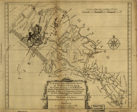
A survey of the northern neck of Virginia, being the lands belonging to the Rt. Honourable Thomas Lord Fairfax Baron Cameron, bounded by
& within the Bay of Chesapoyocke and between the rivers Rappahannock and Potowmack: With the courses of the rivers Rappahannock and
Potowmack, in Virginia, as surveyed according to order in the years 1736 & 1737.
CREATED/PUBLISHED:
[n.p., 1747?]
NOTES:
Scale ca. 1:875,000.
Relief shown pictorially.
Annotated to show roads, plantations, counties and towns. DLCA
A downloaded jpg2 version of this map is to be found here
Dan Guzy, author of numerous articles on the history of the Potomac River, including “The Potomac River Survey of 1822,” in the Maryland Historical Magazine, Winter 2009, points out that the provenance and attribution of this map, and those associated with the disputes over the boundaries of Lord Fairfax's grant of the Northern Neck of Virginia as surveyed by William Mayo, Benajmin Winslow and John Warner between 1736 and ca. 1747, are uncertain and conflicting.
According to Dan Guzy, Benjamin Winslow’s Potomac River map was published in James W. Foster’s “Maps of the First Survey of the Potomac River , 1736-1737” (William and Mary College Quarterly Historical Magazine, Vol. 18, No. 2, April 1938). Benjamin Winslow’s field notes (Mss11:3 W7326:1) are in the Thorton Perry collection at the Virginia Historical Society in Richmond", with a copy at the Berkeley County (WV) Historical Society." See: Elizabeth Cometti, “Concerning the First Survey of the Northern Neck” (West Virginia History, Vol. 2, No. 1, October 1940, pages 59-64).
Dan Guzy notes that "Fairfax Harrison’s “The Northern Neck Maps of 1737-1747” (William and Mary College Quarterly Historical Magazine, Vol. IV, No. 1, January 1924) discussed the Mayo and Warner maps as distinct “rival maps.” Mayo worked for the Crown (i.e., for Lt. Governor Gooch of Virginia ) and Warner, like Benjamin Winslow, worked for Lord Fairfax. Harrison quoted William Byrd (one of three commissioners on the Crown side) as saying Mayo’s map was formed “by joining all the particular surveys together.” Harrison said: “The map [i.e., Mayo’s, the Crown’s map] so identified was 32x32 inches in size, drawn on a scale of 5 miles = 1 inch, and bore the following legend: “A Map of the Northern Neck in Virginia, The Territory of the Right Honourable Thomas Lord Fairfax; Situate betwixt the Rivers Potowmack and the Rappahannock, according to the late Survey; Drawn in the year 1737, by Wm. Mayo.” [This is the same title as Foster used for the “Mayo” map in the Pratt library.]
Harrison described the Warner map as “no less than 42x80 inches in size, and represented a scale of 2½ miles = 1 inch. On its face it was ascribed as ‘Drawn by John Warner, Surveyr.’ Moreover, it carried the following certificate: “A true and accurate Survey of the Rivers Rappahannock and Patowmack to their first heads or Springs, done by order of the Commissioners as well as on the part of His Majesty as the Lord Fairfax. “CH. Carter, W. Beverly , W. Fairfax .” [These were the three commissioners for Lord Fairfax]. Harrison went on to say that Warner’s map was printed in a reduced size, 12x14 inches, so that it could be more easily handled by the King’s Privy Council."
Edward B. Mathews provides some clues to the mystery of these maps in his "Bibliography and Cartography of Maryland Resources," in the 1897 annual report of the Maryland Geological Survey, pp. 344-345, entries for 1737, 1738, and 1745, introducing another map maker, Thomas Lewis, adding further to the confusion. The principal contemporary source for the mapping of the Potomac, apart from Winslow's notes, cited above, is William Byrd's History of the Dividing Line, cited by Mathews. In 1898, in the annual report of the Maryland Geological Survey, Mathews writes extensively about "The "Mayo" map, 1736-7," pp. 388-391, based upon the William Byrd's account and his own observations of the map Byrd included in his work attributed to Mayo.
As Dan Guzy points out, the John Warner map at the Library of Congress has annotations on it later than 1747 (it depicts Fort Cumberland). Someone has annotated the LC copy that it is the 4th edition of the Warner map. It is stamped indicating acquisition? '1947' and there are two stamps indicating it came from the 'Bancroft' collection. [ecp 2009/08/25]
The Maryland State Archives has photostatic copies of two of the survey maps from the British National Archives (formerly the PRO) plus two other copies of the survey maps, one from the New York Public Library:
MSA SC 1427-1-1350, Cartographer: John Warner, 1737 & 1737, Disbound original map, A survey of the northern neck of Virginia, being the lands belonging to the Rt. Honourable Thomas Lord Fairfax Baron Cameron, bounded by & within the Bay of Chesapoycke and between the Rivers Rappahannock and Potowmack published in…
MSA SC 1399-1-305, Cartographer: William Mayo, 1737, A Map of the Northern Neck in Virginia, the Territory of the Right Honourable Thomas Lord Fairfax; situated betwixt the Rivers Patomack and Rappahanock photostat made from original in the Public Record Office, National Archives, Kew, Surrey, United Kingdom.
MSA SC 1399-1-328, Cartographer: John Warner, 1737, A Survey of the Northern Neck of Virginia, being the Lands belonging to the Right Honourable Thomas Lord Fairfax Baron Cameron photostat made from copy owned by Library of Congress Maps Division, produced from an original in the New York Public Library.
MSA SC 1399-1-381, Cartographer: William Mayo, 1737, A Map of the Northern Neck in Virginia situated betwixt the Rivers Potomack and Rappahanock photostat made from original in the Public Record Office, National Archives, Kew, Surrey, United Kingdom. A color version of this map is provided hereby Dan Guzy.
