MSA SC 5339-11-1
|
|
1986
|
|
|
|
Contact the Department of Special Collections for location.
|
Description
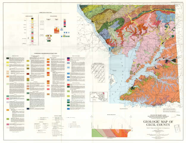
SPECIAL COLLECTIONS (Maryland State Archives Map Collection) Geologic Map of Cecil County, 1986, MSA SC 1427-1557SL 02-12185, S050001799
|
|
MSA SC 5339-11-2
|
|
1950
|
|
|
|
Contact the Department of Special Collections for location.
|
Description
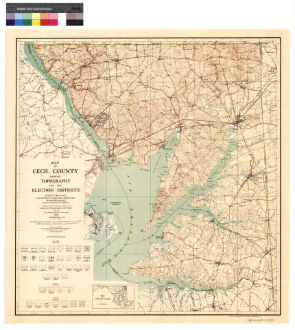
SPECIAL COLLECTIONS (Maryland State Archives Map Collection) Map of Cecil County Showing Topography and Election Districts,
1950, MSA SC 1427-1-2391
SL 02-12955, S050001847
|
|
MSA SC 5339-11-3
|
|
1858
|
|
|
|
Contact the Department of Special Collections for location.
|
Description
07-093a Simon J. Martenet. Map of Cecil County [photostat].MSA SC 1399-1-395 MSA S 1604-2-17373 Posted 2/25/02
CD S050001976 & S050001977
|
|
MSA SC 5339-11-4
|
|
1858
|
|
|
|
Contact the Department of Special Collections for location.
|
Description
07-093b Simon J. Martenet. Map of Cecil County, 1858 [SCAN from a negative]MSA SC 1213-1-462 Posted 4/16/02
Tifs CD S050001950
|
|
MSA SC 5339-11-5
|
|
1858 [?]
|
|
|
|
Contact the Department of Special Collections for location.
|
Description
07-093c Simon J. Martenet. Map of Cecil County [reproduction].
MSA SC 1427-1-2758
MSA S 1604-2-18946 Posted 4/11/02
2 Images on CD S050002121
1 image on CD S050002122
|
|
MSA SC 5339-11-6
|
|
1858
|
|
|
|
Contact the Department of Special Collections for location.
|
Description
Simon J. Martenet, Map of Cecil County, 1858, Library of Congress, MSA SC
1213-1-462.
LOC images on Disk CD S050002269
4 images stitched
Posted 6/20/02
CD Pending
|
|
MSA SC 5339-11-7
|
|
1986
|
|
|
|
Contact the Department of Special Collections for location.
|
Description
SPECIAL COLLECTIONS (Maryland State Archives Map Collection) Geologic Map of Cecil County, 1986, MSA SC 1427-1557SL 02-12185, S050001799
|
|
MSA SC 5339-11-8
|
|
1950
|
|
|
|
Contact the Department of Special Collections for location.
|
Description
SPECIAL COLLECTIONS (Maryland State Archives Map Collection) Map of Cecil County Showing Topography and Election Districts,
1950, MSA SC 1427-1-2391
SL 02-12955, S050001847
|
|
MSA SC 5339-11-9
|
|
1858
|
|
|
|
Contact the Department of Special Collections for location.
|
Description
07-093a Simon J. Martenet. Map of Cecil County [photostat].MSA SC 1399-1-395 MSA S 1604-2-17373 Posted 2/25/02
CD S050001976 & S050001977
|
|
MSA SC 5339-11-10
|
|
1858
|
|
|
|
Contact the Department of Special Collections for location.
|
Description
07-093b Simon J. Martenet. Map of Cecil County, 1858 [SCAN from a negative]MSA SC 1213-1-462 Posted 4/16/02
Tifs CD S050001950
|
|
MSA SC 5339-11-11
|
|
1858 [?]
|
|
|
|
Contact the Department of Special Collections for location.
|
Description
07-093c Simon J. Martenet. Map of Cecil County [reproduction].
MSA SC 1427-1-2758
MSA S 1604-2-18946 Posted 4/11/02
2 Images on CD S050002121
1 image on CD S050002122
|
|
MSA SC 5339-11-12
|
|
1858
|
|
|
|
Contact the Department of Special Collections for location.
|
Description
Simon J. Martenet, Map of Cecil County, 1858, Library of Congress, MSA SC
1213-1-462.
LOC images on Disk CD S050002269
4 images stitched
Posted 6/20/02
CD Pending
|
|
MSA SC 5339-11-13
|
|
1835
|
|
|
|
Contact the Department of Special Collections for location.
|
Description
MSA SC 1399-1-658-1, John C. Trautwine, Map and Profile Route of the Wilmington and Susquehanna Railroad, 1835
Note: Proposed route through Maryland focuses on Elkton in Cecil County.
MSA SC 1399-1-658-2, John C. Trautwine, Address upon a proposed Rail-road from Wilmington to the Susquehanna, together with a Report of the Survey made by William Strickland, Esq., Architect and Engineer, 1835.
Scanned as part of work order MSA SC 5458-51-4614.
|
|
