MSA SC 5339-2-1
|
|
1876
|
|
|
|
Contact the Department of Special Collections for location.
|
Description
Hopkins Atlas, Baltimore County Vol 1, Plate S
|
|
MSA SC 5339-2-2
|
|
1876
|
|
|
|
Contact the Department of Special Collections for location.
|
Description
Gray's New Map of Baltimore.
|
|
MSA SC 5339-2-3
|
|
1850
|
|
|
|
Contact the Department of Special Collections for location.
|
Description
Thomas Cowperthwaite & Co., A New Map of Maryland and Delaware with their Canals, Roads, and Distances.
|
|
MSA SC 5339-2-4
|
|
1851
|
|
|
|
Contact the Department of Special Collections for location.
|
Description
John Tallis & Co., London. United States, plate 69, with Washington Monument.
|
|
MSA SC 5339-2-5
|
|
1898
|
|
|
|
Contact the Department of Special Collections for location.
|
Description
Bromley Atlas of Baltimore County, Part of the 3rd, 8th, & 9th Districts, plate 19.
|
|
MSA SC 5339-2-6
|
|
1672
|
|
|
|
Contact the Department of Special Collections for location.
|
Description
John Smith, Map of Virginia. Bleau derivative.

|
|
MSA SC 5339-2-7
|
|
1825/01/13
|
|
|
|
Contact the Department of Special Collections for location.
|
Description
Will of John Fishpaw, signed June 14, 1814
BA Register of Wills, 12:84
|
|
MSA SC 5339-2-8
|
|
1832/08
|
|
|
|
Contact the Department of Special Collections for location.
|
Description
Jones Falls & Roland Run August 1832. Pen and Ink drawing, 2001. See: Middling Planters of Ruxton 1694-1850, Maryland Historical Society, 1996, for references used in the creation of this drawing.
|
|
MSA SC 5339-2-9
|
|
1838
|
|
|
|
Contact the Department of Special Collections for location.
|
Description
05-077b Thomas G. Bradford. Maryland, 1838.MSA SC 5460-1-2 MSA S 1604-2-18355 Posted 3/25/02
CD S050002090
Thumb on CD S050002130
|
|
MSA SC 5339-2-10
|
|
1819 [1824]
|
|
|
|
Contact the Department of Special Collections for location.
|
Description
05-058 Fielding Lucas, Jr. Maryland, 1824.MSA SC 5460-1-1 MSA S 1604-2-18356 Posted 4/9/02
CD S050002099
CD S050002087
Thumb on CD S050002130
|
|
MSA SC 5339-2-11
|
|
1838
|
|
|
|
Contact the Department of Special Collections for location.
|
Description
08-124b Thomas G. Bradford. Baltimore, 1838.MSA SC 5460-1-3 MSA S 1604-2-18357 Posted 3/19/02
CD S050002049
|
|
MSA SC 5339-2-12
|
|
1671
|
|
|
|
Contact the Department of Special Collections for location.
|
Description
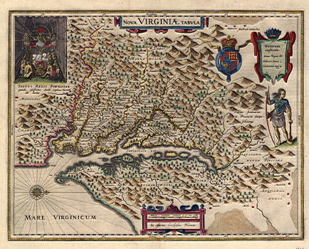
01-003 John Ogilby, Nova Virginiae Tabula, 1671, Joseph M. Coale Collection MSA SC 5339-2-12.
MSA S 1604-2-18358 Posted 3/20/02
CD S050002049
|
|
MSA SC 5339-2-13
|
|
1780
|
|
|
|
Contact the Department of Special Collections for location.
|
Description
La Porte Carte de la Virginie et du Maryland, plate 27, from Atlas Portatif, Paris, 1780.
See: J. DE LA PORTE "Mappe Monde ou
Description du Globe Terrestre, Assujettie aux Observ(s)
Astronomi(s)", plate 2, Paris. 1780. (From Atlas Mod.Portatif). 7X8¾.
Colored. Attractive small map in double
hemispheres showing North & South America & the Pacific in the
Western Hemisphere; and Europe, Africa, India,
China, Asia & Australia in the Eastern
Hemisphere. The east coast of Australia is still not shown and is
still depicted joined to New Guinea in the north, while
Tasmania is still part of the mainland of the
continent in the south. Very decorative title cartouche with leaves,
flowers & scrolls appears at the top of the map,
between 2 hemispheres.
from:
http://www.gracegalleries.com/World_Polar_Projections%20Listings.htm
MSA S 1604-2-19253 Posted 3/21/02
CD S050002050
|
|
MSA SC 5339-2-14
|
|
2001
|
|
|
|
Contact the Department of Special Collections for location.
|
Description
Samuel's Hope, 1840, print by Gordon M. & Sandra L. Callison.MSA SC 5416-1-4 Posted 5/30/02
CD S050002334-5
|
|
MSA SC 5339-2-15
|
|
1999
|
|
|
|
Contact the Department of Special Collections for location.
|
Description
Rockland Village, print by Gordon M. & Sandra Callison.MSA SC 5416-1-3 Posted 5/30/02
CD S050002334-5
|
|
